Interested in riding transit but not sure where, when, or how? Use the RideNoCo Trip
Planner, email the RideNoCo team, or call (970) 514-3636 for help. Additionally, our
local transit agencies provide travel trainings to those interested in learning how to
ride the bus.
The North Front Range region comprises three separate fixed-route transit agencies, operated by the region’s three large communities, and one demand-response service. CDOT currently operates the Bustang service, connecting Fort Collins and Loveland to Denver.
Transit is an important part of the growth anticipated to occur in Northern Colorado over the next 25 years. As a result, all transit agencies in the region are part of either the Larimer County Mobility Committee (LCMC) or the Weld County Mobility Committee (WCMC). COLT, GET, and Transfort, the three large transit agencies, are also active members of the Technical Advisory Committee (TAC) as alternates for the three large cities.
Regional Transit Corridors (RTCs)
As part of the 2050 Regional Transportation Plan, the Planning Council adopted a new set of Regional Transit Corridors (RTCs). RTCs are corridors that connect multiple communities, provide premium transit, or are otherwise important to local communities and the State. The RTCs include 16 corridors, including two potential corridors for the Front Range Passenger Rail. A map of the corridors is included below the table.
Regional Transit Corridors
| Corridor | Category | Name |
|---|---|---|
| RTC-1 | Premium Transit Analysis | Great Western |
| RTC-2 | Premium Transit Analysis | US34 |
| RTC-3 | Premium Transit Analysis | Loveland to Windsor |
| RTC-4 | Existing Service | FLEX Express |
| RTC-5 | Existing Service | FLEX Local |
| RTC-6 | Existing Service | Bustang |
| RTC-7 | Existing Service | Poudre Express |
| RTC-8 | Local Priority | North College MAX |
| RTC-9 | Local Priority | West Elizabeth MAX |
| RTC-10 | Local Priority | Harmony Road MAX |
| RTC-11 | Local Priority | US34 Business Premier Transit |
| RTC-12 & RTC-13 | Front Range Passenger Rail | Front Range Passenger Rail |
| RTC-14 | Local Priority | US85 Transit Service |
| RTC-15 | Local Priority | SH56 Transit Service |
| RTC-16 | Local Priority | US34 West Loveland to Estes Park |
COLT
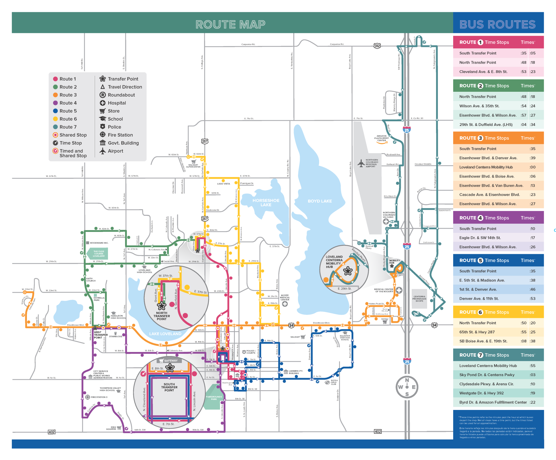
![]() The City of Loveland Transit (COLT) system is operated by the City of Loveland’s Public Works Department. COLT’s fixed-route service runs from 6:38 a.m. to 7:48 p.m., Monday through Friday and from 8:38 a.m. to 5:38 p.m. on Saturday, with half-hour to one-hour headways. Paratransit is available during the same hours for eligible passengers. Seven routes provide service from two main transfer centers: Loveland Transit Center and the South Transfer Center on 8th Street. The City of Loveland also provides funding for the FLEX service between Fort Collins, Longmont, and Boulder.
The City of Loveland Transit (COLT) system is operated by the City of Loveland’s Public Works Department. COLT’s fixed-route service runs from 6:38 a.m. to 7:48 p.m., Monday through Friday and from 8:38 a.m. to 5:38 p.m. on Saturday, with half-hour to one-hour headways. Paratransit is available during the same hours for eligible passengers. Seven routes provide service from two main transfer centers: Loveland Transit Center and the South Transfer Center on 8th Street. The City of Loveland also provides funding for the FLEX service between Fort Collins, Longmont, and Boulder.
GET
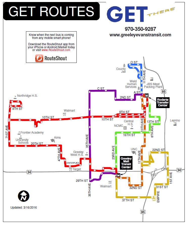
![]() Greeley-Evans Transit (GET) is operated by the City of Greeley and provides fixed-route, paratransit services, and Call-N-Ride, to the public within Greeley, Garden City, and Evans. Service to Evans and Garden City is provided through an Inter-governmental Agreement (IGA). All University of Northern Colorado students are able to ride free with their ID.
Greeley-Evans Transit (GET) is operated by the City of Greeley and provides fixed-route, paratransit services, and Call-N-Ride, to the public within Greeley, Garden City, and Evans. Service to Evans and Garden City is provided through an Inter-governmental Agreement (IGA). All University of Northern Colorado students are able to ride free with their ID.
The Ride Free with ID program was extended to all students in Greeley and Evans. Students can show their student IDs to bus drivers, obtain a free school year pass, or show their state-issued ID to the drivers. The service has allowed students to participate in a variety of after school activities they were not able to previously.
In 2016, GET updated its route system, which replaced the previous one-way loops with bi-directional linear routes.

Transfort
![]() Transfort is the largest transit agency in the region, serving the City of Fort Collins. The service has seen record growth in the past five years, specifically after the opening of the MAX bus rapid transit line and partnering with Colorado State University to provide students with free service. Currently the system has 22 routes as shown in the map below.
Transfort is the largest transit agency in the region, serving the City of Fort Collins. The service has seen record growth in the past five years, specifically after the opening of the MAX bus rapid transit line and partnering with Colorado State University to provide students with free service. Currently the system has 22 routes as shown in the map below.
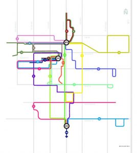
In 2014, Transfort opened the MAX bus rapid transit route along the Mason Corridor. The route operates in its own right-of-way between Harmony Road and Prospect Road, then a shared corridor through CSU’s campus and on Mason Street in Old Town Fort Collins. The route runs every 10-minutes throughout the day and provides important connections at the Downtown Transit Center and the South Transit Center.
BATS
![]() The Berthoud Area Transportation Service (BATS) has been operated by the Town of Berthoud since 2006. BATS provides shared-ride demand-response service for residents in an approximately eight square mile service area. The service area includes the developed portion of Berthoud and the immediate area surrounding the Town.
The Berthoud Area Transportation Service (BATS) has been operated by the Town of Berthoud since 2006. BATS provides shared-ride demand-response service for residents in an approximately eight square mile service area. The service area includes the developed portion of Berthoud and the immediate area surrounding the Town.
BATS transports riders to Longmont on Mondays, with trips to Loveland provided each Tuesday through Friday. Out-of-town rider pickups begin at 8:00 a.m., with a return trip to Berthoud at 11:30 a.m. In-town trips are provided from 8:00 a.m. to 4:00 p.m., Monday through Friday. There is no service on holidays and any rides must be scheduled at least 24-hours in advance.
CDOT/Bustang
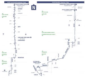
![]() The Bustang‘s North Line service operates between the Downtown Transit Center, Harmony Road Park-n-Ride, US 34 Park-n-Rde, and Denver Union Station. Operating eight round-trips per day, Bustang provides interregional service between Northern Colorado and the Denver Metro. At Denver Union Station, riders can connect to the RTD bus, light rail, and commuter rail system. At both stops in Fort Collins, riders can connect to the Transfort system, and in Loveland, to the COLT system.
The Bustang‘s North Line service operates between the Downtown Transit Center, Harmony Road Park-n-Ride, US 34 Park-n-Rde, and Denver Union Station. Operating eight round-trips per day, Bustang provides interregional service between Northern Colorado and the Denver Metro. At Denver Union Station, riders can connect to the RTD bus, light rail, and commuter rail system. At both stops in Fort Collins, riders can connect to the Transfort system, and in Loveland, to the COLT system.
Bustang Outrider provides service between Sterling and Greeley, operating a three-day-per-week roundtrip.
Questions or Comments?
You may direct transit-related questions or comments to Jerome Rouser, AICP at jrouser@nfrmpo.org or (970) 422 1096.